- Watershed: Morice
- Difficulty: Difficult
- Trail Length: 8.54 km
- Round Trip: 7-10 hours
- Distance from Houston: 60km+
- Cell Coverage: No
- WARNING: Never venture out into the back country without proper gear and emergency provisions.
Amenities
Sorry no amenities for this adventure
Links and Downloads
Description:
Backcountry Route hikes are only for the most advanced and experienced hikers. The trails featured as “routes” are generally not marked in the bush and have no posted signs. These routes are merely suggestions of how to get up the mountain. Advanced navigational skills will be required. A combination of GPS data, spatially referenced digital maps, as well as a compass will be necessary for the best success. There are no amenities in the wilderness. Never venture out into the back country without proper gear and emergency provisions.
Nanika Mountain:
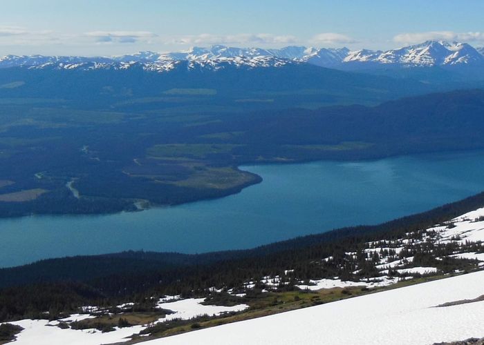
Standing at 1889m, Nanika Mountain is located at the northern terminus of the Morice Range and overlooks the north end of Morice Lake. It provides amazing views of the interior-coastal mountains. Some of the sights you can see are Nadina Mountain, Sibola Range, Kidprice Range, Morice Range, Mount Loring, Titanium Peak, Howson Range and the pristine Crystal Creek Valley…. Just to name a few.
This alpine environment will amaze you with patches of whitebark pine, mountain hemlock, fields of wildflowers and a healthy population of Mamots. Use caution when on Nanika Mountain and the Morice Range, Grizzly bears frequent the range feed on the local plants and marmot colonies.
If you are looking for an extended expedition, once you reach Nanika Mountain, the rest of the Morice Range is easily accessible and contains rolling hills and alpine plateaus. There are plenty of soft spots to camp. Keep a clean camp and be “bear aware”.
There are no directional or trail head signs for this site, use your map and GPS.
DIRECTIONS: (approx 80.9km from Houston)
- Head South of town on the Morice River Rd
- At 27km turn right
- After the 44km bridge turn right onto the Morice-West FSR
- After the 65.5km Bridge that crosses the Morice River, turn left onto the Silver-Tip Road
- At approximately 3km turn right onto the Fisher Rd
- Park at the deactivated bridge, located approx 5.2km up the Fisher Rd